Satellite Altimetry
Post Doc at IFM - University of Hamburg (01/2013 - ongoing)
Sea Level Climate Change Initiative (SLCCI)

In Phase 2 of the SLCCI project, the work of now WP5110 will add another 3 assimilation runs using the GECCO2 model for iterations 23-28:
1) GECCO2 assimilating the usual AVISO product
2) GECCO2 assimilating the new SL CCI product Version V1.1
3) GECCO2 assimilating SL CCI V1.1 and other ECV from the CCI project
These comparisons will allow for an in depth analysis of the improvement of the Sea Level dataset V1.1 compared to the previous AVISO product.
In Phase 1 of the SLCCI project, the work of WP4210 will focus on the comparison of existing GECCO2 solutions with the two data sets SL_ECV_V0 and SL_ECV_V1 (ECV - Essential Climate Variable),
and a respective analysis of residuals that emerge in both cases.
Post Doc at IFM - University of Hamburg (08/2011 - 01/2012)
Using again JTP satellite altimeter data I investigated the Probability Density Functions of the geostrophic velocities that are now available for both geostrophic velocity components. The resulting paper is still in preparation and will include estimates of skewness and kurtosis to quantify whether or not the velocities are normal distributed.
Post Doc, EAPS - MIT (07/2010 - 07/2011)
During the one year stay at MIT in Cambridge, working with Carl Wunsch in the Earth, Atmospheric and Planetary Sciences Department, I further investigated the geostrophic velocity fields of JTP to deepen the knowledge about the frequency and wavenumber spectra of the geostrophic velocity field.
Using the JTP-data set it had been possible for the first time to get insight into the spectra of both velocity components separately, without the assuming isotropy, and without prior
gridding of the Sea Surface Height fields (SSH).
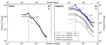
The frequency and wavenumber spectra can be seen in Scharffenberg and Stammer (2011).
Doctoral Thesis, IFM - University of Hamburg (11/2005 - 04/2010)
Within my doctoral thesis I used satellite altimeter data to infer large scale geostrophic velocities from the Jason-1 - TOPEX/Poseidon (JTP) tandem
mission. The JTP tandem mission covers the 3-year time period from 09/2002 until 09/2005 where the altimeter satellites Jason-1 and TOPEX/Poseidon (successor of J-1) were
flying next to each other with a separation of about 1.4° in latitute.
I was especially interested in the sesonal cycle of both velocity components.
Additionally to the published papers and my thesis I provide animations of the annual part of the large-scaleg geostrophic flow field and the resulting annual part of the EKE.
[Click on the animations to enlarge.]